


Cusseta, Chambers County, Alabama
About
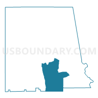
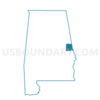
Outline

Summary
| Unique Area Identifier | 521325 |
| Name | Cusseta |
| County | Chambers County |
| State | Alabama |
| Area (square miles) | 51.28 |
| Land Area (square miles) | 50.97 |
| Water Area (square miles) | 0.31 |
| % of Land Area | 99.39 |
| % of Water Area | 0.61 |
| Latitude of the Internal Point | 32.78950920 |
| Longtitude of the Internal Point | -85.32904290 |
Maps

Graphs
Select a template below for downloading or customizing gragh for Cusseta, Chambers County, Alabama


Neighbors
Neighoring Voting District (by Name) Neighboring Voting District on the Map
- Fairfax/Langsdale/Riverview/Shawmut/ Hughley Voting District, Chambers County, AL
- LaFayette, Chambers County, AL
- Lakeview/Lanett/Huguley Rescue Voting District, Chambers County, AL
- Opelika B Voting District, Lee County, AL
- Pine Grove United Meth Church Voting District, Lee County, AL
- Sturkie Voting District, Chambers County, AL
Top 10 Neighboring County Subdivision (by Population) Neighboring County Subdivision on the Map
- Auburn-Opelika CCD, Lee County, AL (80,779)
- Valley CCD, Chambers County, AL (13,966)
- Lanett CCD, Chambers County, AL (9,961)
- Beulah CCD, Lee County, AL (6,705)
- La Fayette CCD, Chambers County, AL (5,427)
- Waverly CCD, Chambers County, AL (1,242)
Top 10 Neighboring Place (by Population) Neighboring Place on the Map
Top 10 Neighboring Unified School District (by Population) Neighboring Unified School District on the Map
- Lee County School District, AL (56,237)
- Chambers County School District, AL (27,747)
- Opelika City School District, AL (26,477)
Top 10 Neighboring State Legislative District Lower Chamber (by Population) Neighboring State Legislative District Lower Chamber on the Map
- State House District 79, AL (52,950)
- State House District 38, AL (44,337)
- State House District 37, AL (43,958)
Top 10 Neighboring State Legislative District Upper Chamber (by Population) Neighboring State Legislative District Upper Chamber on the Map
Top 10 Neighboring 111th Congressional District (by Population) Neighboring 111th Congressional District on the Map
Top 10 Neighboring Census Tract (by Population) Neighboring Census Tract on the Map
- Census Tract 417, Lee County, AL (8,528)
- Census Tract 418, Lee County, AL (6,705)
- Census Tract 9540, Chambers County, AL (6,669)
- Census Tract 9543, Chambers County, AL (4,708)
- Census Tract 9542, Chambers County, AL (3,257)
- Census Tract 9539, Chambers County, AL (2,900)